
BUFFALO, N.Y. — When it comes to this year's winter forecast in Buffalo, several factors could influence what type of weather systems the region sees, the overarching temperature trend, and how much snow could fall this year compared to last.
To be discussed: The return of a La Niña, what second-year La Niña winters have brought in the past, the impact of warm lake temperatures, if the lake will freeze over, and if it really has snowed more within this past decade or decades before.
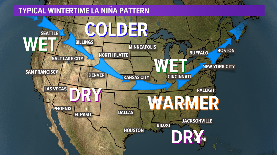
One of the main drivers of climate is the El Niño Southern Oscillation, which is expected to be in a negative or cooler phase this winter. That’s called La Niña.
This unusually cold water by the equatorial Pacific can influence the position of the jet stream across North America. Now, this usually makes more of a difference in other areas of the country, compared to its effect on Western New York. But typically, a La Niña winter will bring a bit more precipitation, and temperatures will be slightly warmer around the Great Lakes.

And sometimes, we can use data from previous La Niña years as a benchmark for what we could face in the future if a certain pattern repeats itself. This time around, there's a timeframe when there were two back-to-back La Niñas of similar strength that we can reference when thinking about this winter.
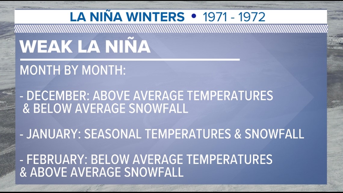
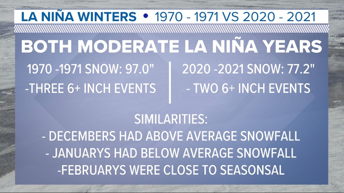
Those two winters were 1970-1971 and 1971-1972, when the setup went from a moderate La Niña for the winter of 1970-1971 to a weak La Niña for 1971-1972, which could match what happened last winter and to this winter.
The winter that followed the moderate La Niña from 1970-1971 started off with a mild December, seasonal January, and snowy and cold February. Of course, that doesn’t mean those exact results will happen this year, but it’s good to reference this when we know that pattern was last in place.

We had another similar situation in the winter of 2011-2012, but that time around, it was the year winter really never showed up. That year was also a weak La Niña coming after a moderate one the year before, but it turned out to be a real non-winter with only about 36 inches of snow for the Buffalo Airport.
That winter was the warmest November to March on record; we had the fewest number of days with an inch of snowfall, and the fewest days below freezing. It was crazy warm on St. Patrick’s Day, and many remember the parade in the 70s. But locally, the El Niño Southern Oscillation's pattern and circulation is not the only thing you can look at and predicting a winter forecast.

Now, every winter, our attention turns to Lake Erie and how it will impact our winter season. You'll hear us talking about how warm the lake is during the month of November, and how a warm and wide open Lake Erie is a key ingredient for lake effect snow events.
As the cold air settles into Western New York, we then turn our attention to whether Lake Erie will freeze over. Once the lake does freeze over, the potential for severe and strong lake effect snows diminish, since a major component in the formation of lake effect snow has been taken offline.
According to the Great Lakes Environmental Research Laboratory, the last time Lake Erie was completely frozen over, from end to end, was in 1996. Since that time, we've had ice coverage as low as 5.4 percent in 1998 and as much as 98.1 percent in 2015.
And as for snow, after looking at eight decades of snowfall totals from the 1940s to 2020, the numbers show that while our earth may be getting warmer, our snowfall totals per decade have remained pretty much the same.
Actually, the decade with least amount of snow was the 1940s. Buffalo received 779.9 inches of snow from 1940 to 1950. That's an average of about 77.99 inches per year. Buffalo's snowiest decade on record goes to 2000-2010 with 1,057.6 inches of snow, or an average yearly amount of 105.8 inches.
So, based on this local analysis, and taking into account historic trends, here's what Storm Team 2 is thinking could be a valid outlook for this winter.
For the months of December through February, temperatures will likely be slightly above average again. But don't rule out a cold-air outbreak or two, as seen in several La Niña years too.
We know we’re going to get some snow and will likely have a handful of big snow events too. Mostly synoptic and widespread snow events, but if the lake doesn't completely freeze over, that leaves the door open for lake effect events all the way through February or March.