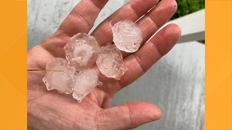
BUFFALO, N.Y. — Reports of penny to tennis ball-sized hail fell from severe thunderstorms over Niagara County Tuesday evening.
For that large of hail, there had to be something "out of the ordinary" for Kansas-type hail to fall in Western New York.
Here's Storm Team 2's hypothesis:
For the past few days, you may have noticed a hazy appearance in the sky, illuminated by a setting "red sun" or rising "red moon." Both were caused by smoke being present in the atmosphere, settling in over Western New York thanks to a favorable weather pattern that brought the smoke from wildfires out west.
We believe it's the smoke, too, that lead to abnormally large hail developing within some of those strong thunderstorms Tuesday evening. Here's how.
Precipitation develops within clouds when water vapor particles are able to cool and condense, thus taking on a liquid form. In the summer, that usually means rain. But when it comes to severe thunderstorms, that can also mean hail.
Hail develops when updrafts of thunderstorm clouds, also know as cumulonimbus clouds, can loft liquid precipitation higher in the sky to a point at which it freezes. Thus creating tiny, frozen hailstones in the updraft. Depending on how strong the storm's updraft is, these hailstones will continue to rise and fall, freezing and unfreezing, and growing in size until they're too heavy and eventually fall to the ground.
But we're missing an important ingredient which is key to understanding how that large of hail, the size of tennis balls (!), was able to develop and grow. That vocabulary word is Cloud Condensation Nuclei.
You may have heard this word before in "Heather's Weather Whys" or "Experiments with Elyse." Defined by the American Meteorological Society's Glossary of Meteorology, Cloud Condensation Nuclei (CCN) are hygroscopic aerosol particles that serve as nuclei for atmospheric cloud droplets.
Translation: Cloud Condensation Nuclei (CCN) are the "building blocks" of clouds. They are microscopic particles of dust, ash, smoke and even pollen that are high in the sky. They base for which water vapor molecules use to go from vapor to liquid form. And there can be a direct correlation between how many cloud condensation nuclei there are in the sky to how much rain falls or how large hail can grow.
Bingo! With a noticeable and large amount of smoke, therefore lots of CCN, in the sky, Storm Team 2 believes that those thunderstorms that developed Tuesday evening were able to use all the extra CCN to their advantage by producing a lot of rain and extremely large hail for this part of the country.
Reports of tennis ball-sized hail at 2.5 inches in diameter fell in Lewiston and ping pong ball-sized of 1.5 inches in diameter not too far in Lockport.
These storms also producing a lot of rain, and you can thank that CCN for that too. Radar estimations were coming in around 3 to 5 inches for Tuesday's rain over the Niagara Frontier. That lead to another round of flash flooding and a State of Emergency being issued by Niagara County.
RELATED VIDEO: