BUFFALO, N.Y. — We’re coming off a pretty decent stretch of hot, humid weather in Western New York. But our six days in the mid 80s is nothing compared to the dangerous heat people in the Pacific Northwest have been dealing with since Sunday.
Until this week, the city of Seattle had only hit 100 degrees twice in recorded history. Monday marked the third day in a row of 100 degrees plus. Two of those days set new all time high temperatures records. That record was previously 103 degrees. Sunday reached 104. Monday reached 108.
And Seattle wasn’t alone. Dozens of other cities in the Pacific Northwest set some astonishing records too, including Portland, which hit 116 degrees. The town of Lytton in British Columbia, Canada, reached 118 two days in a row. That is now the hottest temperature recorded anywhere in Canada.
Those temperatures are 35 to 45 degrees higher than normal for the area. To put that in perspective, Buffalo’s temperatures would be in the 110 to 120-degree range with this type of setup!
So how in the world did this happen? As usual with weather, it’s a combination of several factors from short-term weather patterns to long-term climate trends.
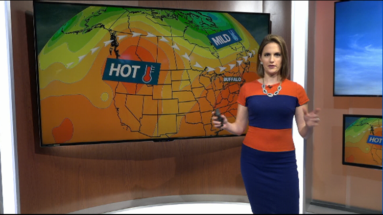
An unusual pattern that many have referred to as a “heat ridge” set up right over the Northwest late last week. Over a period of a couple of days, that ridge swelled up like a big balloon and blocked all clouds and rain from the region. Underneath that high, sinking air warmed tremendously as it fell in elevation. A law of atmospheric thermodynamics says that sinking air warms, and that was certainly the case here.
That pattern alone would have been enough for some impressive heat, but probably not the all-time records that many have seen. This time, trends in the climate of the Northwest spurred on by global warming added some extra degrees.
Over the last several decades, droughts have been expanding and becoming more extreme in the Western states. Dry ground heats to much higher temperatures than ground with a more substantial amount of water near the surface, and so does the air just above it. That leads to increasing air temperatures which cycles back to intensify the drought cycle.
New episodes of Heather’s Weather Whys are posted to the WGRZ YouTube channel every Wednesday evening.
If you have a weather question for me to answer, send it to heather.waldman@wgrz.com or connect with me on Facebook or Twitter.