BUFFALO, N.Y. — New York Governor Andrew M. Cuomo has directed state agencies to prepare for multiple storm systems that are expected to impact multiple areas through the state with snow, sleep and freezing rain this weekend.
"As we head into New Year's weekend, a series of storms are poised to deliver snow, rain, and freezing rain throughout the state over the next several days," Governor Cuomo said.
"State agencies are already preparing emergency response equipment and stand ready to assist any of our local partners if necessary. New Yorkers should also remember to celebrate smart this year. If anyone is traveling in the coming days, please use extreme caution while driving, especially during the evening and early morning hours, when temperatures may drop below freezing and turn the rain to ice," Cuomo added.
For Western New York, Friday's storm will stay well to the west of Buffalo, keeping our entire region in the "warm sector" New Year's Day. But temperatures just ahead of this system will be cold enough for some freezing rain and sleet to mix with rain as precipitation moves in Friday afternoon.
A Winter Weather Advisory will go into effect at 2pm Friday and last through 12am Saturday for parts of southern Erie, Genesee, Wyoming, Chautauqua, Cattaraugus and Allegany counties
The highest risk for icy conditions will be in northern Pennsylvania as well as the interior Southern Tier and Genesee Valley. This wintry mix may last for several hours and cause travel issues, especially if ice is able to accumulate on surfaces.
Temperatures will slowly rise through Friday night, and should eventually be high enough for all parts of Western New York to switch over to plain rain that will last through Saturday morning. This rain may be heavy at times. Scattered showers remain possible through the afternoon.
Rainfall totals with this second storm may reach one inch in some spots. That much rain combined with snow melt will make things very swampy for a couple of days. Localized flooding is a possibility, especially for parts of Erie County that picked up close to two feet of snow last week.
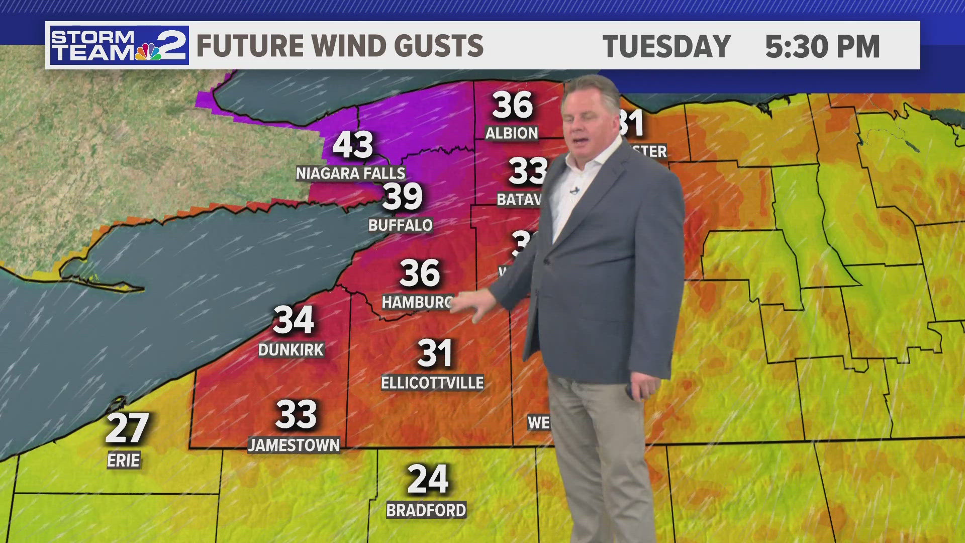
The current forecast track also leaves room for some gusty winds later Friday into Saturday too. The exact track and strength of the storm is what will determine how severe the winds could be. A closer pass with the center of the storm would yield stronger winds, while a pass farther west would lessen the wind threat.